US12578175 - Flight deck unit and safety supervisor for enhanced navigation, fuzing, and guidance of unmanned vehicles or projectiles
The invention describes a flight deck unit designed for unmanned vehicles, enabling advanced navigation, fuzing, and guidance capabilities, particularly in environments where GPS may be compromised. It includes a safety supervision system that ensures weapon systems remain inactive within predefined safety zones, enhancing operational security and reliability.
Claim 1
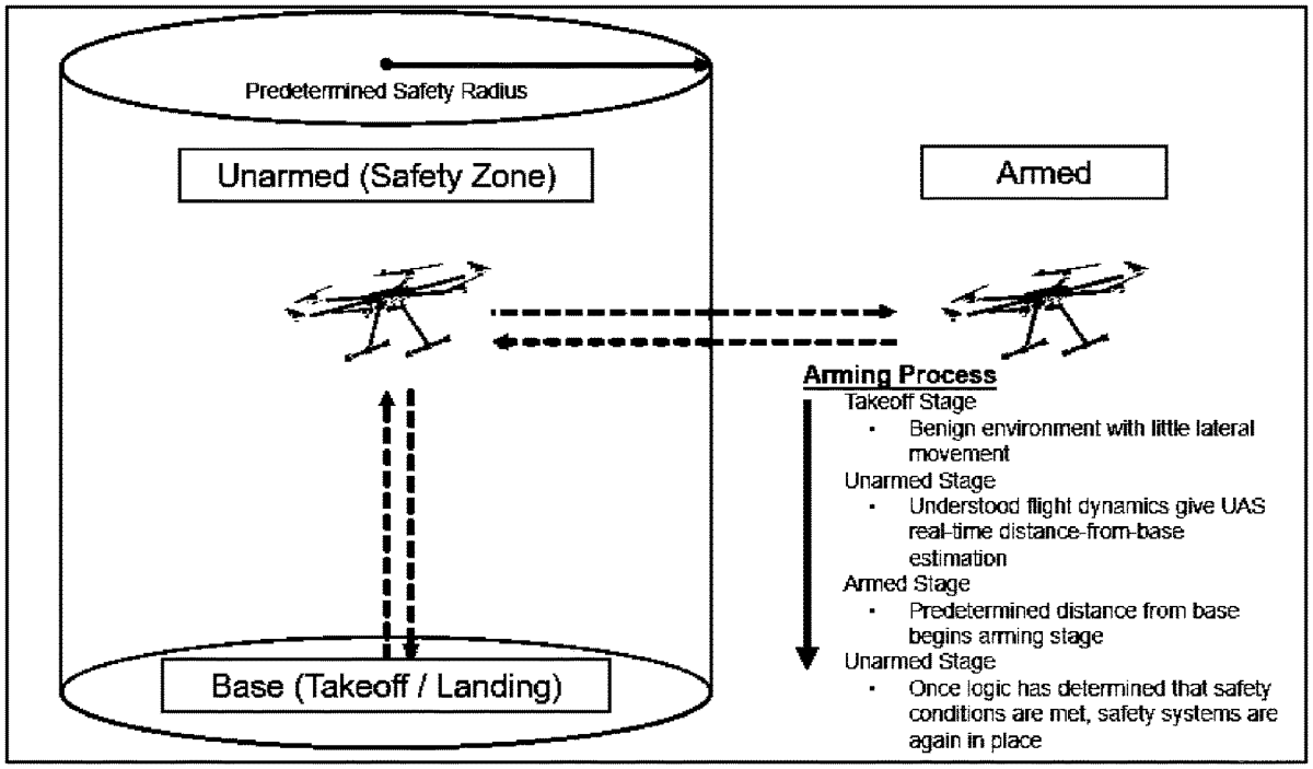
1 . A guidance, navigation and weapons fuzing system comprising: an unmanned aerial vehicle (UAV) comprising at least one visible spectrum image sensor adapted for acquiring visible image data, at least one infrared (IR) image sensor adapted for acquiring infrared image data, and at least one altimeter adapted for measuring altitude data of the UAV; at least one processor comprised on the UAV and adapted to: a. receive the visible image data, IR image data, and altitude data, b. process the visible and IR image data to identify and acquire one or more points of interest and define waypoints based on the points of interest, points of interest being identifiable and recognizable features in the visible image data and/or infrared image data, and waypoints being points of interest selected to be used in guidance and navigation of the UAV), c. identify and measure relative distances: i. between the UAV and points of interest, ii. between the UAV and waypoints, and iii. between the waypoints, d. to determine the UAV’s location relative to one or more predefined safe zones, and e. to provide guidance and control commands to the UAV based on the image data, altitude data, and processed data; a transceiver comprised on the UAV and adapted for transmitting at least one or more of the image data types to a second processor at a remote location, and the transceiver is adapted to be off, and not transmitting any data, during flight from takeoff to a target location and during flight from the target location to a home location or a rally point; and an arming and fuzing subsystem comprised on the processor and/or the second processor and adapted to arm and fuze a weapon system based on an arming determination that the UAV is outside of the one or more safe zones and with confirmation from a remote user, the arming determination based on the determination of the UAV’s location relative to the one or more predefined safe zones and the weapon system comprising a projectile or munition releasable from a UAV, wherein the predefined safe zones are areas or regions designated and preprogrammed into the UAV in which the arming and fuzing subsystem is completely unable to arm and fuze the weapon system. an unmanned aerial vehicle (UAV) comprising at least one visible spectrum image sensor adapted for acquiring visible image data, at least one infrared (IR) image sensor adapted for acquiring infrared image data, and at least one altimeter adapted for measuring altitude data of the UAV; at least one processor comprised on the UAV and adapted to: a. receive the visible image data, IR image data, and altitude data, b. process the visible and IR image data to identify and acquire one or more points of interest and define waypoints based on the points of interest, points of interest being identifiable and recognizable features in the visible image data and/or infrared image data, and waypoints being points of interest selected to be used in guidance and navigation of the UAV), c. identify and measure relative distances: i. between the UAV and points of interest, ii. between the UAV and waypoints, and iii. between the waypoints, d. to determine the UAV’s location relative to one or more predefined safe zones, and e. to provide guidance and control commands to the UAV based on the image data, altitude data, and processed data; a. receive the visible image data, IR image data, and altitude data, b. process the visible and IR image data to identify and acquire one or more points of interest and define waypoints based on the points of interest, points of interest being identifiable and recognizable features in the visible image data and/or infrared image data, and waypoints being points of interest selected to be used in guidance and navigation of the UAV), c. identify and measure relative distances: i. between the UAV and points of interest, ii. between the UAV and waypoints, and iii. between the waypoints, i. between the UAV and points of interest, ii. between the UAV and waypoints, and iii. between the waypoints, d. to determine the UAV’s location relative to one or more predefined safe zones, and e. to provide guidance and control commands to the UAV based on the image data, altitude data, and processed data; a transceiver comprised on the UAV and adapted for transmitting at least one or more of the image data types to a second processor at a remote location, and the transceiver is adapted to be off, and not transmitting any data, during flight from takeoff to a target location and during flight from the target location to a home location or a rally point; and an arming and fuzing subsystem comprised on the processor and/or the second processor and adapted to arm and fuze a weapon system based on an arming determination that the UAV is outside of the one or more safe zones and with confirmation from a remote user, the arming determination based on the determination of the UAV’s location relative to the one or more predefined safe zones and the weapon system comprising a projectile or munition releasable from a UAV, wherein the predefined safe zones are areas or regions designated and preprogrammed into the UAV in which the arming and fuzing subsystem is completely unable to arm and fuze the weapon system.
Google Patents
https://patents.google.com/patent/US12578175
USPTO PDF
https://image-ppubs.uspto.gov/dirsearch-public/print/downloadPdf/12578175