US12435958 - Real-time shot detection and scoring based on target image processing
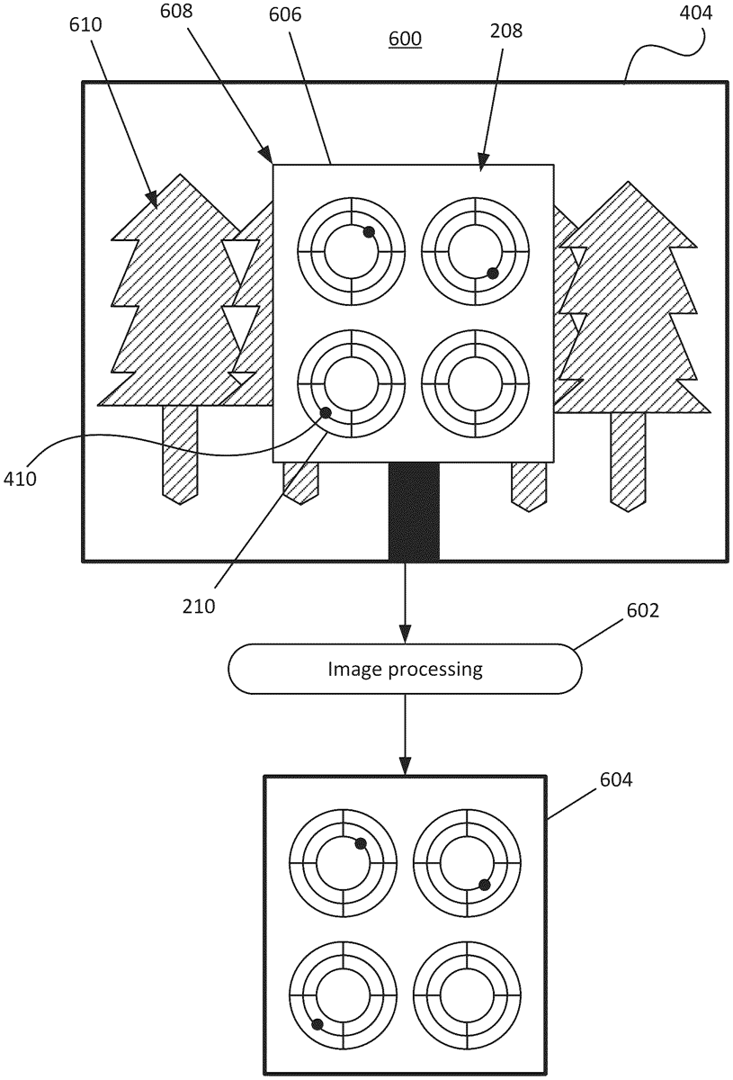
The patent describes an electronic target measurement system that utilizes image capture devices to acquire real-time images of a target, allowing for the extraction of regions of interest and locations of impact. The system processes these images to determine scores based on the distance between the center points of the regions and impacts, providing a comprehensive scoring mechanism for shooting accuracy.
Claim 1
- An electronic target measurement system comprising: at least one image capture device each configured to: generate low-resolution image data and high-resolution image data of a series of successive real-time images of at least one target with a plurality of regions of interest (ROIs), wherein the series of successive real-time images includes a primary image and a secondary image taken at a predetermined amount of time after the primary image; an access point device electrically coupled with the at least one image capture device and configured, in each measurement cycle, to: determine whether the system is in a first mode or a second mode, based on whether the system is in the first mode or the second mode, receive the low-resolution image data or the high-resolution image data of the primary and secondary images from the at least one image capture device, and transmit to the user device the low-resolution image data in the first mode and the high-resolution image data in the second mode; and a user device electrically coupled with the access point device and configured to: display the low-resolution image data as image stream on a user interface of the user device in the first mode, perform image preprocessing on the high-resolution image data of the primary and secondary images in the second mode, determine, via an image differentiation process performed on the high-resolution image data of the primary and secondary images, that the secondary image is different from the primary image, extract the plurality of ROIs and one or more locations of impact (LOIs) from the high-resolution image data of the secondary image, determine, for each of the plurality of extracted ROIs, a ROI center point, any one of the one or more LOIs within the ROI, and a LOI center point for the corresponding LOI, determine, for the each of the plurality of extracted ROIs, a regional score based on a distance between the ROI center point the LOI center point, and determine a total score by adding the regional scores for the plurality of extracted ROIs. at least one image capture device each configured to: generate low-resolution image data and high-resolution image data of a series of successive real-time images of at least one target with a plurality of regions of interest (ROIs), wherein the series of successive real-time images includes a primary image and a secondary image taken at a predetermined amount of time after the primary image; generate low-resolution image data and high-resolution image data of a series of successive real-time images of at least one target with a plurality of regions of interest (ROIs), wherein the series of successive real-time images includes a primary image and a secondary image taken at a predetermined amount of time after the primary image; an access point device electrically coupled with the at least one image capture device and configured, in each measurement cycle, to: determine whether the system is in a first mode or a second mode, based on whether the system is in the first mode or the second mode, receive the low-resolution image data or the high-resolution image data of the primary and secondary images from the at least one image capture device, and transmit to the user device the low-resolution image data in the first mode and the high-resolution image data in the second mode; and determine whether the system is in a first mode or a second mode, based on whether the system is in the first mode or the second mode, receive the low-resolution image data or the high-resolution image data of the primary and secondary images from the at least one image capture device, and transmit to the user device the low-resolution image data in the first mode and the high-resolution image data in the second mode; and a user device electrically coupled with the access point device and configured to: display the low-resolution image data as image stream on a user interface of the user device in the first mode, perform image preprocessing on the high-resolution image data of the primary and secondary images in the second mode, determine, via an image differentiation process performed on the high-resolution image data of the primary and secondary images, that the secondary image is different from the primary image, extract the plurality of ROIs and one or more locations of impact (LOIs) from the high-resolution image data of the secondary image, determine, for each of the plurality of extracted ROIs, a ROI center point, any one of the one or more LOIs within the ROI, and a LOI center point for the corresponding LOI, determine, for the each of the plurality of extracted ROIs, a regional score based on a distance between the ROI center point the LOI center point, and determine a total score by adding the regional scores for the plurality of extracted ROIs. display the low-resolution image data as image stream on a user interface of the user device in the first mode, perform image preprocessing on the high-resolution image data of the primary and secondary images in the second mode, determine, via an image differentiation process performed on the high-resolution image data of the primary and secondary images, that the secondary image is different from the primary image, extract the plurality of ROIs and one or more locations of impact (LOIs) from the high-resolution image data of the secondary image, determine, for each of the plurality of extracted ROIs, a ROI center point, any one of the one or more LOIs within the ROI, and a LOI center point for the corresponding LOI, determine, for the each of the plurality of extracted ROIs, a regional score based on a distance between the ROI center point the LOI center point, and determine a total score by adding the regional scores for the plurality of extracted ROIs.
Google Patents
https://patents.google.com/patent/US12435958
USPTO PDF
https://image-ppubs.uspto.gov/dirsearch-public/print/downloadPdf/12435958