US12724167 - System and method for UXO detection
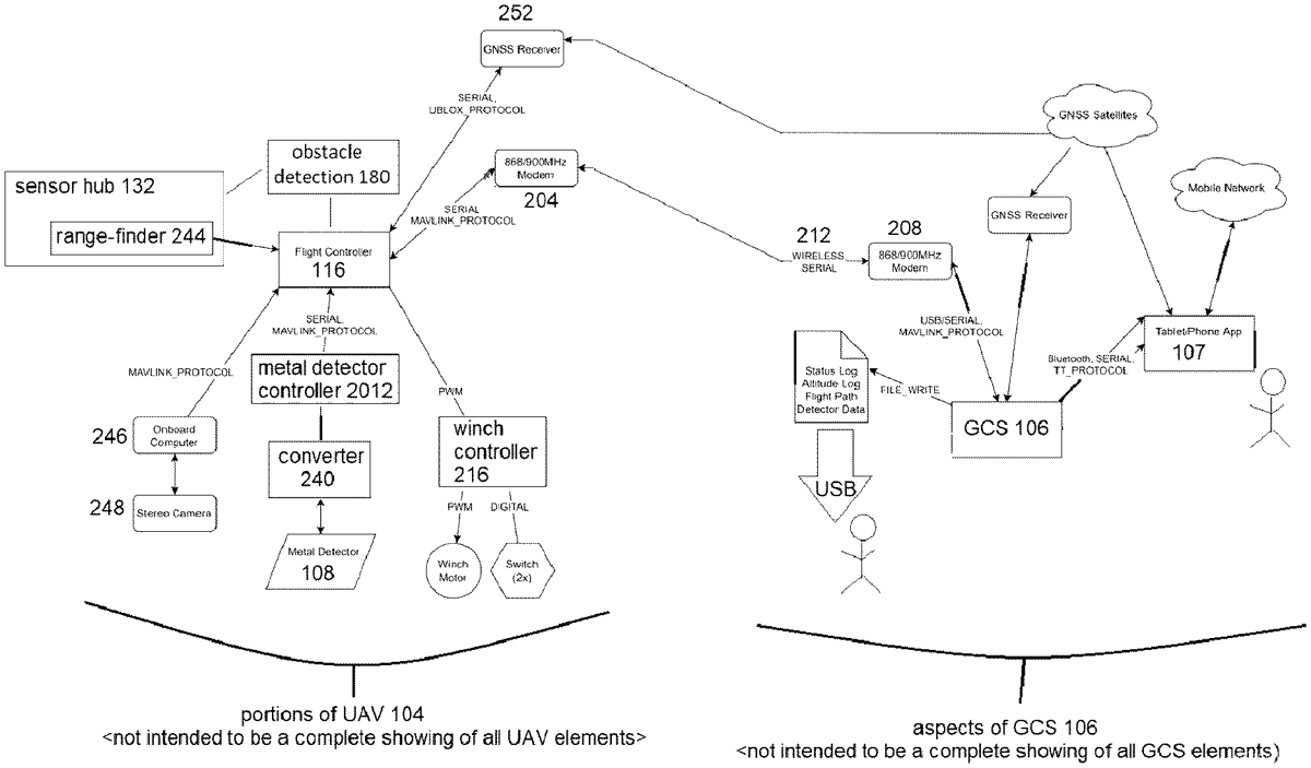
The patent describes a system and method for detecting unexploded ordnance (UXO) using a customized unmanned aerial vehicle (UAV) equipped with various sensors and a ground control station. It emphasizes precise mission planning and obstacle avoidance capabilities, enabling the UAV to operate effectively at low altitudes while gathering and processing UXO data.
Claim 1
1 . A method of structuring and configuring a system for detecting unexploded ordnance (UXO), comprising: configuring a ground control system (GCS) to work with a pre-configured unmanned aerial vehicle (UAV), the UAV comprising a flight controller, a metal detector, and a sensor hub; configuring a tablet with a mobile app loaded thereupon for facilitating human usage of the GCS; the GCS assisting a user in defining one or more land boundaries to be searched for UXO; the GCS controlling a flight plan of the UAV; all data-acquisition and data-management tasks performed by the UAV, including data and communications related to geographic data, flight plan, all terrain data obtained, and all UXO data obtained; and the GCS controlling the UAV using a specific predetermined methodology of obtaining UXO information available in the user-defined land-boundary; the mobile app providing GUIs for the user to plan UXO detection missions ahead of time either off-location or on-location; the mobile app providing a GUI to select a New Mission and facilitating entry of desired plurality of mission parameters; and configuring the plurality of mission parameters comprising sensor altitude over ground, and lane spacing; combining metal detector data with position data from the UAV at the time the reading was taken; factoring that both GPS receiver and metal detector have different delays from the point a measurement is taken until received at the GCS; a metal detector controller operating and updating the metal detector; configuring the metal detector controller with predetermined logic for interpreting the differing delays and aligning them; and fusing/combining the UXO and terrain data and combining position data with metal detector data; equipping the UAV with one or more stereo vision cameras for calculating a depth of field; the two cameras performing obstacle detection partly by forming a 3D image of what is in front of the UAV and conveying that information to an obstacle detection and avoidance module; the obstacle detection and avoidance module processing visual information; the obstacle detection and avoidance module sending data about obstacles to the GCS including how the UAV may avoid that obstacle; the GCS then directing a travel path of the UAV and the UAV not being self-directed; the obstacle detection and avoidance module utilizing information obtained from the sensor hub. configuring a ground control system (GCS) to work with a pre-configured unmanned aerial vehicle (UAV), the UAV comprising a flight controller, a metal detector, and a sensor hub; configuring a tablet with a mobile app loaded thereupon for facilitating human usage of the GCS; the GCS assisting a user in defining one or more land boundaries to be searched for UXO; the GCS controlling a flight plan of the UAV; all data-acquisition and data-management tasks performed by the UAV, including data and communications related to geographic data, flight plan, all terrain data obtained, and all UXO data obtained; and the GCS controlling the UAV using a specific predetermined methodology of obtaining UXO information available in the user-defined land-boundary; a flight plan of the UAV; all data-acquisition and data-management tasks performed by the UAV, including data and communications related to geographic data, flight plan, all terrain data obtained, and all UXO data obtained; and the GCS controlling the UAV using a specific predetermined methodology of obtaining UXO information available in the user-defined land-boundary; the mobile app providing GUIs for the user to plan UXO detection missions ahead of time either off-location or on-location; the mobile app providing a GUI to select a New Mission and facilitating entry of desired plurality of mission parameters; and configuring the plurality of mission parameters comprising sensor altitude over ground, and lane spacing; combining metal detector data with position data from the UAV at the time the reading was taken; factoring that both GPS receiver and metal detector have different delays from the point a measurement is taken until received at the GCS; a metal detector controller operating and updating the metal detector; configuring the metal detector controller with predetermined logic for interpreting the differing delays and aligning them; and fusing/combining the UXO and terrain data and combining position data with metal detector data; equipping the UAV with one or more stereo vision cameras for calculating a depth of field; the two cameras performing obstacle detection partly by forming a 3D image of what is in front of the UAV and conveying that information to an obstacle detection and avoidance module; the obstacle detection and avoidance module processing visual information; the obstacle detection and avoidance module sending data about obstacles to the GCS including how the UAV may avoid that obstacle; the GCS then directing a travel path of the UAV and the UAV not being self-directed; the obstacle detection and avoidance module utilizing information obtained from the sensor hub.
Google Patents
https://patents.google.com/patent/US12724167
USPTO PDF
https://image-ppubs.uspto.gov/dirsearch-public/print/downloadPdf/12724167